|
|
Booking.com | ||||||||||||||||||||||||||||||||||||||||||||||||||||||||||||||||||||||||||||||||||||||||||||||
LeirvíkGeneral information - Location
Nearest 5 places
Nearest 3 capitals
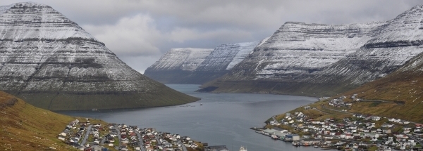
Characteristics - Physical GeographyLeirvík lies at the Atlantic Ocean (direction NorthEast). The nearest bigger lake is Eiðisvatn (0.9 km2 at a distance of 18.5 km in NorthWestern direction).The place is located at an island named Eysturoy. The distance to the mainland is 392.9 km.Elevation around place: very low location (near sea level): 3%, low location: 81%, hill: 17%, The hills are mainly flatern orientated. The surroundings of the place have a rural character (very sparsely urbanised). Nearby scheduled flights are operated from (national) airport Bergen Airport, Flesland (at a distance of 673 km and direction EastSouthEast).The closest smaller (subnational) airport is Vágar Airport (at a distance of 34 km in WestSouthWestern direction). Climate - Temperature and Precipitation |
Location of Leirvík in country Faroe-islands
Leirvík at Physical map (height map)Tourist information - Travel GuideNearest 3 UNESCO-sites
Social media - Maps
|
||||||||||||||||||||||||||||||||||||||||||||||||||||||||||||||||||||||||||||||||||||||||||||||
Relief: Altitude classes in percent (within 5km)Relief: slope classes in percent (within 5km) |
Current weather at Eystur
Weather coming 24 hoursEystur - FO (longitude: -6.7157, latitude: 62.2151)Distance weather station to place (direction N): not known
|
||||||||||||||||||||||||||||||||||||||||||||||||||||||||||||||||||||||||||||||||||||||||||||||
5 days Weather forecast: Temperature - Pressure and PrecipitationPressure (mbar)
Wind speed (km/h)
hours
Cloud cover %
precipitation (mm)
hours
|
|||||||||||||||||||||||||||||||||||||||||||||||||||||||||||||||||||||||||||||||||||||||||||||||
|
Widget is loading comments...
|
|||||||||||||||||||||||||||||||||||||||||||||||||||||||||||||||||||||||||||||||||||||||||||||||
| number of views: 368 | |||||||||||||||||||||||||||||||||||||||||||||||||||||||||||||||||||||||||||||||||||||||||||||||


 Leirvík


 ©
© 


 Filming Location


